DOSSIER OF OUR ROUTE, IT WILL BE VERY USEFUL IF YOU DECIDE TO VISIT IT AND YOU CAN’T OR DON’T WANT TO GO TO THE CIVV!
A bit of history
The line from Peñarroya to Fuente del Arco and from Peñarroya to Puertollano was an indy-mining narrow-gauge railway built by the French multinational Sociedad Minera y Metalúrgica de Peñarroya (SMMP) in different phases between 1895 and 1927 in order to make profitable the exploitation of the coal, lead and zinc mines that this company had in Badajoz, northern Cordoba and Ciudad Real. The connection of the mines with the Cerco Industrial de Peñarroya-Pueblonuevo, where the company had an important processing, metallurgical and chemical industry thanks to this railway and, in turn, the link through the terminus stations with other Iberian gauge lines such as Seville-Merida and Cordoba-Madrid allowed, on the one hand, the export of processed products to foreign countries and, on the other, their sale in the capital of Spain.
The line reached a maximum length of 243 kilometres and was considered the second longest in Spain in its category. After various economic vicissitudes resulting from the closure of mining operations and competition from road transport, the SMMP ceded the line to the State in 1956. Finally, FEVE closed it in 1970.
Technical specifications
Location: between Peñarroya-Pueblonuevo and Villanueva del Duque.
Length: 38,5 kilometres.
Users: suitable for everyone, although there are occasional slopes at kilometre 8, 23 and 34.
Natural Environment: starlight reserve, dehesa World Heritage Site, Designation of origin ptrotegida Los Pedroches.
Cultural Heritage: Industrial Fences of Peñarroya-Pueblonuevo and civil buildings related to the metallurgical industry (French quarter, mining hospital, La Dirección building), Belmez castle, granite architecture in Villanueva del Duque.
Infrastructure: 1 viaduct, 3 railway stations reclaimed.
How to get there: public transport. Peñarroya-Pueblonuevo, Belmez and Villanueva del Duque: Autocares San Sebastián. Connections: Córdoba 70 km. to Peñarroya-Pueblonuevo. GPS coordinates 38º 20’N 5º 3’W.
This itinerary has been prepared by the Vías Verdes programme of the Diputación de Córdoba, the Confederación hidrográfica del Guadiana and the Caminos Naturales programme of the Ministry of Agriculture, Fisheries and Food.
Type of road surface: Peñarroya-Belmez (7 kilometres) compacted earth: Belmez-Estación de Cámaras Altas (9 kilometres) compacted earth and asphalt; Estación de Cámaras Altas-Estación de Minas del Soldado (24 kilometres) compacted earth.
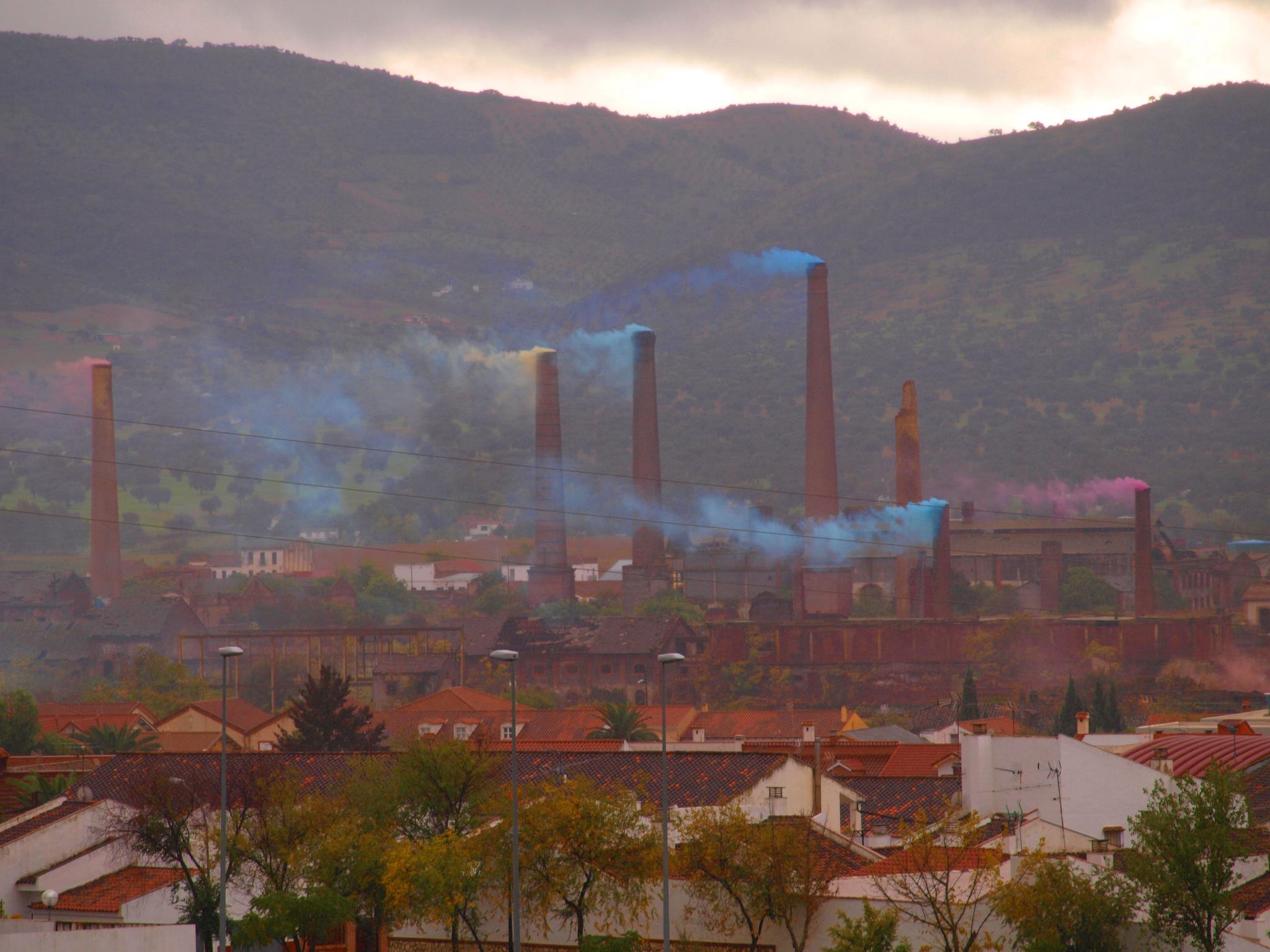
Peñarroya-Pueblonuevo’s Industrial Fences: an enchanted forest of chimneys
The main objective of the transformation of the old railway lines in the Guadiato region into a greenway has been to facilitate public access to the old working areas used for mining and industry, as well as to promote their environmental recovery. Of all of them, the most significant from a heritage point of view are the Peñarroya-Pueblonuevo Industrial Enclosures. At 800,000 square metres and 160 years old, they are considered one of the most interesting landscapes of its kind in Western Europe.
Currently, these monuments have been protected by the Junta de Andalucía since 2017 as an Asset of Cultural Interest.
The Guadiato and Los Pedroches Greenway and other trails of railway origin allow you to visit this forest of chimneys and factory buildings that was so important in the industrial history of Andalusia and universal history, since much of the lead used to manufacture the weapons of the First World War and the chemicals with which the Allied army gassed the troops of the Central Empires were manufactured here.
Every December, during the festivity of Santa Bárbara, since 2011 the Association La Maquinilla in collaboration with the Town Council of Peñarroya-Pueblonuevo lights the 9 chimneys of the Industrial Fences with coloured smoke, a tradition halfway between a show and a demand for their preservation.
Route through one of Spain’s most important Industrial Heritage Sites.
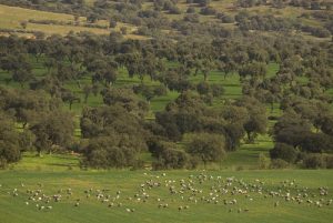
The Guadiato and Los Pedroches Greenway starts at the Cerco Industrial de Peñarroya-Pueblonuevo. It passes through centuries-old mining shafts and open-cast mines transformed into artificial lakes, followed by pastures where the Iberian pigs are reared in the wild, producing the best hams in the country. Its municipal district is located in the Minas del Soldado de Villanueva del Duque station, a typical village of the Pedroches Valley with white houses and granite walls.
The route
The Greenway is the product of the unification of various recovered sections of the same railway, the Fuente del Arco-Peñarroya-Puertollano, which were independent greenways (La Maquinilla in 2013, La Minería and Peñarroya-Pueblonuevo in 2015 and El Cerco in 2018) until 2020 when they began to be connected with funds from the Provincial Council of Cordoba and the Ministry of Agriculture, Fisheries and Food. At the date of finalisation of this guide, there are works underway between kilometre 17 and 25 to connect some of these sections. As an alternative, it is recommended that you use the A-3175 regional road and a public road that crosses the impressive Cámaras Altas public park.
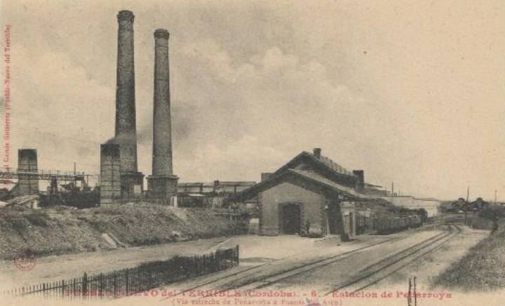
There are currently 2 information and rest points for users: the first is located in Peñarroya-Pueblonuevo, in the guardhouse of the Pueblonuevo del Terrible railway station, at kilometre 2. It is a visitor reception point managed by the La Maquinilla Association, a citizens’ platform that manages the care and development of the route; a second point is located in the former Belmez-ermita station. It is a restaurant with a swimming pool that opens between April and September.
Peñarroya-Pueblonuevo, welcome to the Vía Verde del Guadiato y Los Pedroches!
The route begins at the Central Warehouse of the Cerco Industrial de Peñarroya-Pueblonuevo, a cathedral of Eiffelian architecture. Its interior houses a railway museum where you can admire some of the locomotives that plied the lines of this valley transporting the minerals and processed products that were manufactured in this immense industrial space called Cerco. Opposite the Central Warehouse, next to the bus station, there are all kinds of services for the visitor, such as banks, restaurants, department stores, shops and hotels.
From the Central Warehouse there are two options to start the route:
1) To make a circular route through the interior of the Cerco Industrial, starting and finishing at the same point, taking advantage of the railway lines that have been conditioned as a greenway.
2)Start the route in the direction of Villanueva del Duque without passing through El Cerco, crossing the road to the La Estación neighbourhood and following the green and white kilometre markers, which, although they indicate the opposite direction, mark the route as they belong to the Vía Verde de La Maquinilla signpost, whose kilometre 0 was established in the town of Belmez in keeping with the history of this broad gauge line before it was integrated into the Vía Verde del Guadiato and Los Pedroches.
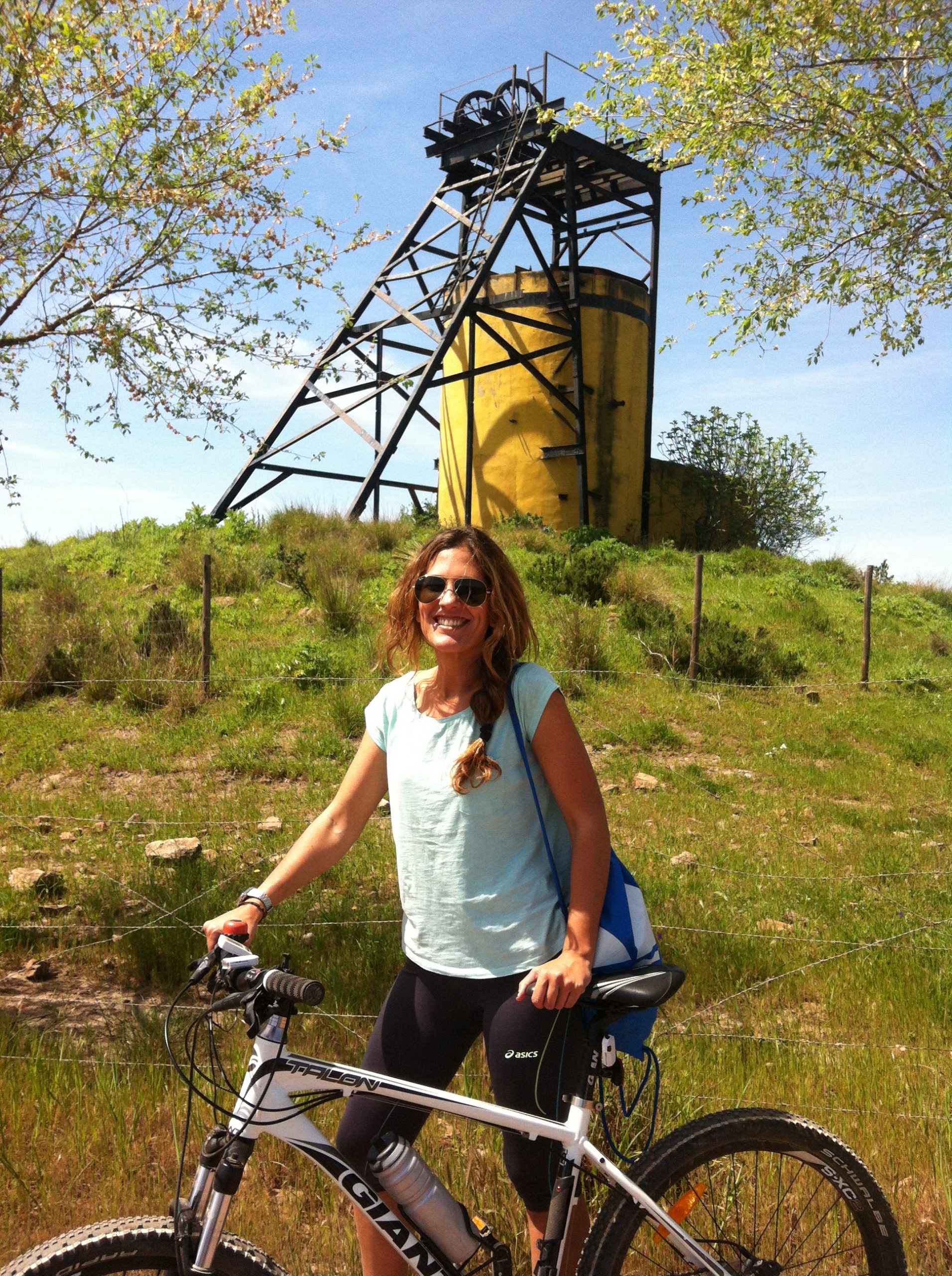
Following the reverse signposting, one kilometre further on, on the right, we find the remains of well number 4, which stands out in the landscape due to its yellow cylindrical casing. It was a coal pit opened at the beginning of the 20th century and closed in 1973. It is sadly famous for having been the scene of a serious accident in the 1960s in which four miners died as a result of the breakage of the cable of the cage that lowered them down.
After turning right, a green lung area of wetlands appears in front of us. These are open-cast mines that have been restored as a peri-urban park. 400 metres further on, there is another turning to the left that leads to a gallery of elm trees for another 400 metres. At the exit of this tree tunnel we come across a reddish, almost Martian territory, full of large rocks. They are the result of the reaction of the burnt coal from the Cerco thermal power station with the atmosphere, which, when it was still incandescent, was taken by rail or lorry to this area. Erosion did the rest, resulting in a special landscape.
Belmez, much more than a castle
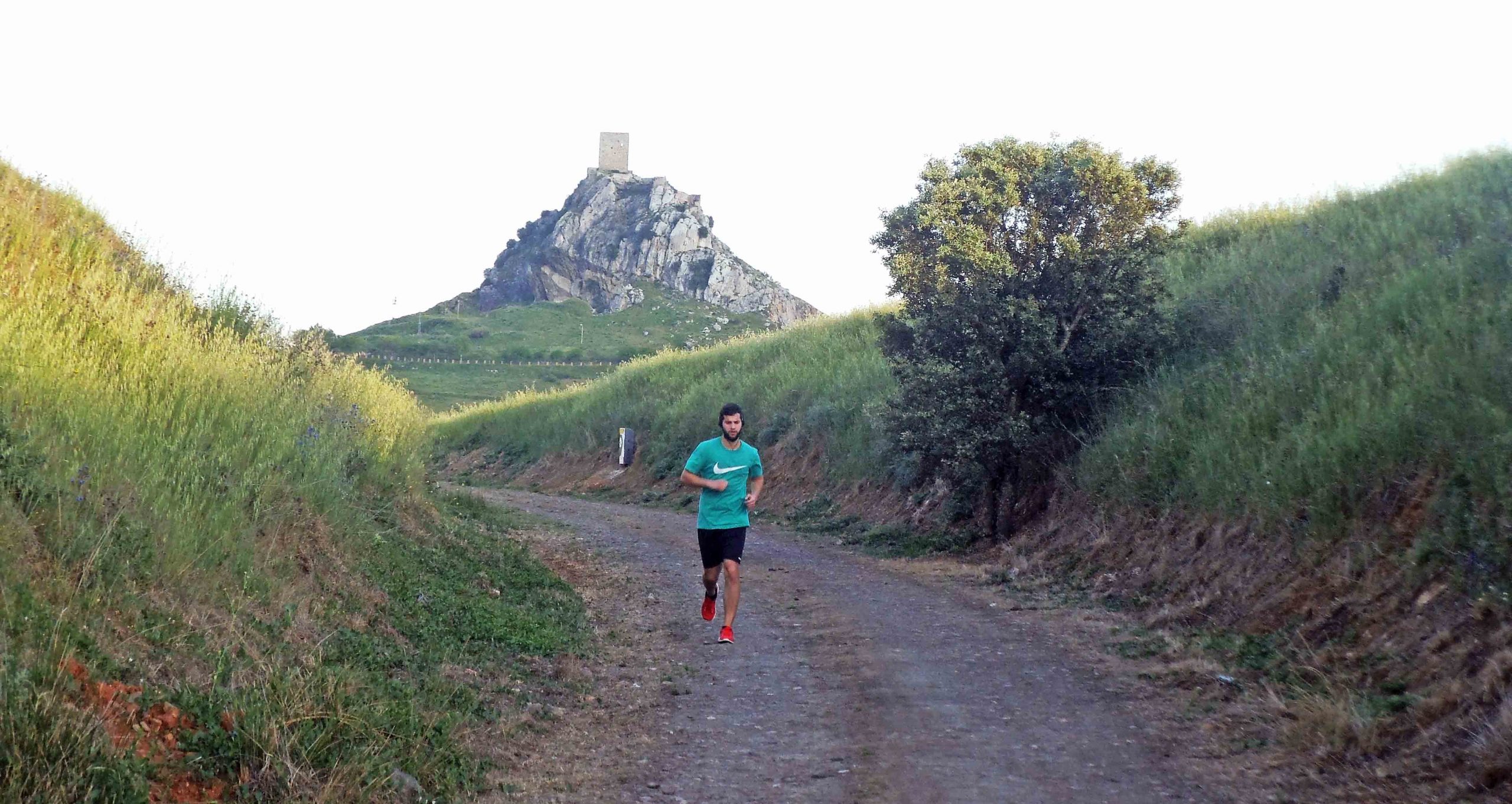
The imposing silhouette of the rocky hill crowned with the castle of Belmez accompanies us throughout the green corridor. It was an exclusively military watchtower of Muslim origin that formed part of a complex of fortifications that guarded the road linking the city of Cordoba with Portugal. After the Reconquest it was abandoned until the War of Independence, when it came to life when it was occupied by French troops.
Once in Belmez, just as we reach the milestone indicating kilometre 1 (this is the 7th kilometre of our route) we come to a rest area next to which there is a picturesque white and red two-storey building that contrasts with the medieval air of the municipality. This is the Belmez-ermita Station, which belonged to the old Peñarroya-Puertollano narrow-gauge railway line on which the Guadiato and Los Pedroches greenway has been built. It has been transformed into a restaurant with a municipal swimming pool where we can enjoy the typical gastronomy of the area made up of tasty meats and meat dishes.
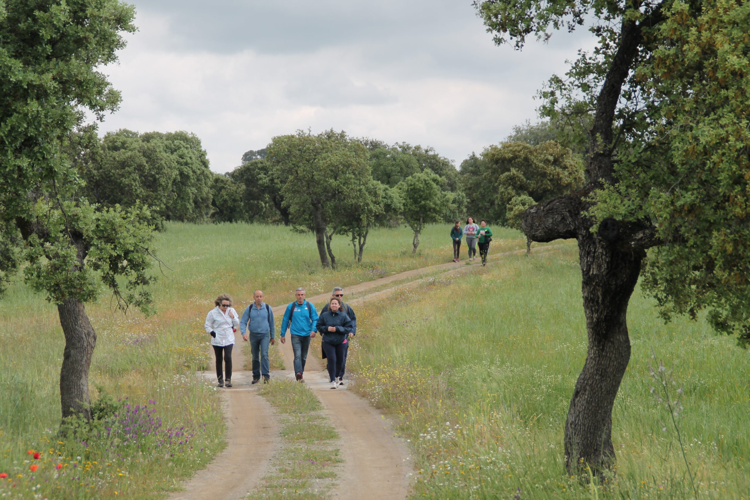
The green cycle lane that runs alongside the station will lead to a crossing. We must take it, turning left, although this means leaving the railway line that brought us here. Continue for 300 metres until you pass under the N-432 bridge. Immediately after passing under the bridge we take a path that goes off to the left. This path connects again with the railway line. From this point onwards the horizon changes from the black and red of the wells and industrial chimneys to the unmistakable green of the Mediterranean forest. Significant patches of holm oaks and gall oaks accompany us and provide shade for 5 kilometres. All this together with the scent of rockrose, thyme and rosemary make this spring route a treat for the senses.
The Aguas Vivas centre, another of the tourist services that bring this route to life, is located here. It offers horse riding routes, riding lessons, a residence for pets and recreational bullfights.
The section combines deep trenches with open spaces that allow us to make out to the right the great stony tusk of Peña Ladrones, which is home to the largest colony of griffon vultures in the province of Cordoba. This point was a refuge for bandits for centuries and here Republican and Nationalist soldiers also found refuge during the Spanish Civil War, during the innumerable changes of front that took place in this sector from 1936 to 1939.
Civil War and gastronomy
The route is abruptly interrupted again by the works on the Vía Verde at kilometre 12 at the factory-built railway bridge over the Arroyo del Risquillo stream. We take the path that connects the bridge with the A-3175 road. Once there we walk 3 kilometres on tarmac until we see the Cámaras Altas Station, formerly an important station on the line from the point of view of agricultural transport. From the eucalyptus forest that protects it, there is a compacted path that we must follow as an alternative to the greenway rehabilitation works. It runs through an area of high ecological value made up of different types of conifers. The site is unique for many reasons:

1) There are fortified buildings from the Spanish Civil War on the surrounding cliffs and hills that can be visited by following the numerous trails that start from the main axis.
2) The níscalo grows here, a mycological delicacy appreciated in a large part of the country.
3) Herds of wild boar and deer can be seen. If you visit the route between September and October you cannot miss the spectacle of the bellowing, the mating ritual of this herbivorous species that is often heard at dusk and nightfall.
From this point, 5 km. of delightful route awaits us along a restored railway platform with slight detours that literally cuts into the sierra. Small, medium and large trenches joined by dense masses of rockrose, holm oaks, cork oaks, gall oaks and, of course, eucalyptus trees, create an intimate and thought-provoking sensation for the visitor. This pleasant monotony of red and green walls is interrupted by the friendly and furtive ambush of the guardhouses, once places for life and work where the workers of the Sociedad Minera y Metalúrgica de Peñarroya (SMMP), in charge of the maintenance of the railway elements, nested. Today they are a sporadic refuge for the leisure of full Spain. Most of them are places for romantic archaeology and anti-capitalist artistic photography.
Last stop: Villanueva del Duque. A walk through the lands where the best ham in Spain is created
Between hut and hut, between watercourse and watercourse, kilometre 30 of the route takes us to the Peñas Blancas Station (1906), set in a landscape of singular beauty. It is currently being restored by the Villanueva del Duque Town Council and is awaiting a service for users of the Vía Verde. There is a rest area here.
From here the cyclist encounters long, flat railway corridors of young holm oaks alternating with winding and fun public paths that “bridge” those sections that could not be saved from being sold to private individuals. Such difficulty does not detract from the value of the route, which has extensive pig farms where pigs are reared in the wild to produce Los Pedroches Denomination of Origin ham, considered the best in Spain on numerous occasions by the Ministry of Agriculture, Fisheries and Food.
Our route ends at the station of another mining operation: Minas del Soldado. The greyish, almost silvery tone of the tailings make us feel like astronauts from the Apollo programme in the middle of a journey to the moon, only on earth. The heaps reach the height of a four-storey block of flats and are the size of several football pitches, which suggests that it was a mining operation out of the ordinary. Not surprisingly, since its closure in 1934, no equivalent vein of lead has yet been discovered in the country that can match it in terms of productivity and wealth.
It is possible to visit the mining fence with caution. From the remains, it is possible to identify the garden dwellings for the engineers, including a tennis court, or a thermal power station that provided energy for the technology used to extract energy from the shafts.
Starlight reserve. Do the greenway also at night
The Guadiato and Los Pedroches Greenway is one of the few in Spain that can be visited both during the day and at night. The entire route is a Starlight reserve, so that you can enjoy the stars at night in one of the clearest night skies in the world. If you want to learn even more about the sky, there is a fabulous astronomical observatory in Villanueva del Duque waiting for you.
Fuente Obejuna, the loose verse
As in Lope de Vega’s universal play, Fuente Obejuna, this town has a recovered section of Via Verde of 7 kilometres on the same railway and is working together to be able to connect to the Vv. del Guadiato and Los Pedroches as soon as possible. This route is well worth a visit to observe migratory birds (ZEPA area) and to admire the excellent historical heritage of this ancient town.
SERVICES IN THE MIDDLE OF THE GREENWAY